Distance : 6.2 miles
Start : St. Mary`s Island, Whitle Bay
Finish: Ferry landing, North Shields
Uncover the unique history and character of the coast from Whitley Bay to North Shields. This walk offers a flavour of everything you could wish for. From birdlife, flowers, history, art, literature, architecture to modern culture there is much for you to enjoy.
Start: St. Mary`s Island, Whitle Bay
In 1739, a certain Michael Curry murdered the landlord of the Three Horse Shoes Inn at Hartley, a village to the north of Whitley Bay, and, following his execution at the Westgate in Newcastle upon Tyne, his body was hung from a gibbet on the headland overlooking St. Mary`s Island.
Since that time the headland has been known as Curry`s Point and a blue plaque, attached to a large piece of sandstone, marks the spot and also the start of this linear walk.
Before commencing your journey south, a trip across the short causeway to St. Mary`s Island, time and tide allowing, will prove worthwhile.
First lit in 1898, the lighthouse, which is so much a part of the local landscape that it was incorporated into the Whitley Bay coat of arms in 1954, is now a visitor centre.
A 137-step climb to the top of the lighthouse is rewarded by superb views.
St. Mary`s Wetland
Once you have returned to the headland, and with your back to the island, head along the promenade, keeping a watchful eye on the rocks below, a favourite feeding and resting place for a host of waders, terns and gulls.
When the promenade curves to the right, climb to the top of the grass bank and you will be adjacent to the St. Mary`s Wetland. This freshwater area attracts a wide variety of birds, some migratory, others who make their home here, so keep a look out for oystercatchers, kestrels, curlews, green sandpipers, yellow wagtails and more.
Brierdene burn
Once the promenade comes to an end, there are two alternative routes. You can either walk along the sandy beach close to the sea or you can keep to the cliff top, along the edge of the miniature golf course. Both routes converge in a short while at the small hump-back, stone footbridge over the Brierdene burn.
This small coastal dene provides an interesting refuge for plants and wildflowers and is dotted with red admiral, small tortoiseshell and painted lady butterflies during the height of the summer.
Northern promenade
Cross over the footbridge and follow the path as it cuts left across the bankside to join the beginning of the northern promenade on the other side.
After little more than 400 metres, you will pass the Rendezvous Café, for so long a much-loved Whitley Bay landmark. The opening lines of Julia Darling`s poem, Rendezvous Café: Whitley Bay perfectly encapsulate the mood of this delightful seaside ice cream parlour:
I would like us to meet
Where the Horlicks is sweet
I could tell you my story
With a knickerbocker glory
Through the archways lies a second, more recent watering hole, the delightful Links Art Café which, as the name suggests sells a range of artworks as well as serving up a range of tasty snacks.
As you continue straight on you will notice a change in the promenade surface and fixtures, one of the many improvements made by the local authority in the recent past, this particular stretch of promenade opening in late 2017.
Very quickly you will pass, on your right, an interesting art décor style drinking fountain, erected in 1937 to commemorate the coronation of King George VI, and then the now eye-catching Panama Swimming Club building, whose hardy members are renowned locally for their traditional New Years Day dip in the sea.
Where a path branches to the right you will see the extremely popular skate board park, and beyond the Panama Gardens. Rather than leave the promenade by the facing stairs, continue straight on until you reach the pretty Ice Cream kiosk with a back-hugging outside seating area.

The Links
As you now climb the gentle path to your right (known as Watts Slope) you will be at the southern end of the large area of open space known as the Links. It is hard to believe that this popular recreation area was, during the early part of the nineteenth century, strewn with colliery heaps and ironstone workings which had become overgrown with gorse.
The work, which ultimately resulted in the current green expanse, was started by the Whitley Bay Golf Club whose members began using the Links in 1890.
Look to your right and you will spot the Cenotaph, the site of the towns’ Remembrance Day services. Further across the Links, there once stood the King George V Coronation Bandstand, built in 1911 and a popular venue for the brass bands of the day. Whilst this was demolished many years ago, the adjacent bus stop area is still referred to as the Bandstand.
The Spanish City
Immediately in front of you stands the unmistakable Dome, as much a symbol of Whitley Bay as the lighthouse on St. Mary`s Island. The Grade II Listed building, whose towers were topped with two female figures clad in animal pelts, one carrying a cymbal and the other a tambourine, formed the centre piece of the Spanish City fairground.
Founded in 1908, the fairground was the entertainment complex around which the seaside resort revolved. In 1980 it gained international fame with the release of the Dire Straits song Tunnel of Love, which conjured up the nostalgic thrills and spills of a trip to the fairground with lines like:
Girl you look so pretty to me
Like you always did
Like the Spanish City to me
When we were kids
The fairground is now closed but the iconic dome has recently undergone massive improvements and it currently houses a number of facilities, including a tea room, a fish and chip restaurant, a wine bar, a local gift shop and an exclusive restaurant.
It is worth a having a peep inside where, on the upper balcony, you will see the original two female figures who used to clash the cymbals and rattle the tambourine on top of the exterior towers.
Continue south, with the sea over to your left, and you will quickly reach Richard Broderick`s functional Sandcastle artwork in front of the Premier Inn and Beefeater Restaurant. This wonderfully relevant work doubles as a seating area, giving some protection from the bracing sea air.
Originally, this work had four metal flags but, alas, two of them went walkabout when the work was temporarily removed during the improvement works.
For much of this walk you will be following the route of the King Charles II England Coast Path (ECP) which, when fully completed, will be the longest managed and waymarked coastal path in the world. This stretch of the ECP was officially opened in July 2018 and is marked, from time to time, with the National Trails acorn symbol. So keep your eyes peeled.
Lower central promenade
Continue along the main promenade with the 1924-built/2018-refurbished Lower Central Promenade below you on the seaward side behind the fine stone balustrade, and in front of you the former Rex Hotel, previously called the Waverley Hotel and once the largest hotel in the area. The renovation of this important landmark building is due for completion in 2025 when it will become a care home.
You are now passing through what was formerly the busy nightlife hub of Whitley Bay and it is not without a touch of irony that the artist, who produced some of the most famous Guinness posters, was born in the town in 1898. Working for the Irish drinks company between 1925 and 1960, John Gilroy created two iconic Guinness images; the workman casually carrying a massive girder on his shoulder and the thirsty sea lion making off with the zoo keeper`s pint.
Esplanade
Just beyond the former hotel, at the bottom of the Esplanade, stands Empire Court an imposing block of recently-built apartments. The building that previously occupied this site was constructed in 1910 and during its long life went through a number of incarnations: the Empire Theatre, the Gaumont Cinema, the Alletsa Ballroom and Sylvesters Nightclub.
The Esplanade provides a direct link between the town`s railway station and the seafront, a fact which undoubtedly influenced proposals to site a pier from the promenade at this point, projecting out into the sea. First planned in 1908, the scheme was abandoned because it was considered that the cast iron columns, which were to support the 270 metre platform and concert pavilion, would not withstand the forces of nature. A much grander scheme was drawn up in 1935 but, once again, the proposals failed to get off the ground.
As you continue to walk south, the promenade rises slowly to its highest point before descending gently through the Rockcliffe area of the town, where the first promenade in Whitley Bay was built in 1893. Below the prominent headland lie the rocks of Brown`s Bay, the scene of many a shipwreck.
Cullercoats
Take the path which leads up the one-sided terrace of Southcliffe towards the headland and follow this until you reach the flight of steps straight ahead of you.
The headland was once the site of the Cullercoats Radio Station and is called Marconi Point, after the Italian scientist who pioneered the use of wireless telegraphy. The former radio station building has now been converted into a house.
Go down the steps, across the short promenade and up the stairs at the other end. At the top you are facing the 1768-built Cliff House, the oldest building in Cullercoats.
Just past the house is the delightful Watch House, a local landmark since 1879, and once the lookout post of the Cullercoats Volunteer Life Brigade. Whilst little of the original village still stands, Cullercoats retains much of its charm with its cosy bay and sandy beach now extremely popular with canoeists and paddle boarders.
There are a number of enticing watering holes dotted around the village so this may be an appropriate spot to rest your feet.
Cullercoats artists
Since the middle of the seventeenth century, coal, salt and fishing have all played an important part in the daily life of the village. Whilst never a tourist destination as such, Cullercoats had, by the late eighteenth century, become well known as an artists` colony, attracting home-grown artists such as Jobling, Emmerson, Birket Foster and Horton.
In 1881, the arrival of Winslow Homer, the leading American water colourist of his generation, ultimately led to Cullercoats becoming known throughout the art-loving world. During his 20 month stay, Winslow Homer produced nearly 150 watercolours and drawings, many of which now hang on the walls of major art galleries across America.
Glance across the road and you will see, affixed to the exterior of the new block of apartments, a blue plaque recording the fact that Homer, on first arriving in Cullercoats, stayed at the hotel which once occupied this site. The apartment block is named in his honour; Winslow Court.
As you reach the corner of John Street and Beverley Terrace you will see the tiny Rocket Garage, once used by the Volunteer Life Brigade for the storage of their carriage and rocket apparatus. The present RNLI lifeboat is housed in a fine building next to the beach, below you on the seaward side.
Tynemouth Longsands
A short walk along the Victorian-built Beverley Terrace brings you to the gloriously golden Tynemouth Longsands, now one of the country`s leading surfing destinations. In 2004, the town hosted the sports` prestigious and hugely successful O`Neill British Nationals.
Standing next to the Beaconsfield public open space, to your right, is St. Georges Church, erected in 1884, by the sixth Duke of Northumberland in memory of his father, George Algernon Percy. In his authoritative 1957 work, The Buildings of England Nikolaus Pevsner thought that the church was, ‘noble, honest and earnest’, adding that ‘such a church is in a way a thirteenth century ideal rarely achieved in the thirteenth century’.
Tynemouth Park
Further along the spacious promenade, after passing the recently renovated Art-Deco style Tynemouth Castle Inn once known as the Park Hotel, lies Tynemouth Park, first laid out in 1893, and opposite is the large, former public shelter, constructed around the same time, and now home to a number of shops and cafes.
The latest addition is the Durano Lounge which now occupies the large space that was, for many years, the much-loved but hopelessly under-funded Toy Museum.
Tynemouth Plaza
Just beyond the shops and cafes, where the grass bank slips down to the beach, lies the site of the former Plaza. Opened in 1879, and totally dominating the seafront, the winter garden and aquarium, was intended as a major tourist attraction. It proved, however, to be a white elephant, as did all subsequent schemes for its use, and eventually, perhaps even fortuitously, the rapidly decaying building was destroyed by fire in 1996 and ultimately erased from the landscape.
Grand Hotel
On the promenade, at the most southerly end of the Longsands, stands the stylish Grand Hotel, built in 1872 as a summer residence for the Duke of Northumberland and then converted into an hotel some five years later.
King Edward’s Bay and Tynemouth Castle
From here the promenade bends away from the beach, climbing gently towards Tynemouth village. Below, to your left, is the beach of King Edwards Bay (also known as the Short Sands), dominated by the high cliffs of Pen Bal Crag, the impressive Tynemouth Castle and the ruins of the seventh century Priory.
Built by the monks of Holy Island and sacked by the Danes, the Priory is the burial place of three kings, Oswin King of Deira, Osred King of Northumbria and Malcolm III King of Scotland.

Tynemouth village
The village of Tynemouth, once the home of the nineteenth century writer Harriet Martineau, has many fine buildings and positively oozes history not to mention a host of restaurants, cafes, shops and public houses. It is justifiably a Conservation Area and deserves further exploration. But, unless you have time and energy to burn, you may wish to leave that for another day.
Priors Haven and North Pier
Your route now follows the road which drops down the hill adjacent to the castle towards the tiny cove of Priors Haven, home to the local sailing club and the landward end of Tynemouth Pier otherwise known as the North Pier.
Collingwood’s monument
Once over the narrow bridge at the foot of the hill, take the signposted gravel track on your right towards the monumental statue of Admiral Lord Collingwood, Nelson`s second in command at the Battle of Trafalgar.
Overlooking the mouth of the River Tyne, the Portland stone statue stands on a John Dobson-designed sandstone pedestal and was installed in 1845 to commemorate Newcastle born Cuthbert Collingwood. The four cannon were taken from Collingwood`s ship at Trafalgar, the Royal Sovereign.
The views from the pedestal, across the River Tyne as far as the distant Penshaw Monument in County Durham, are impressive.
Black Middens
From the top of the bankside make your way down to the river- hugging promenade, as it heads upstream past the notorious Black Middens rocks, a major hazard to ships entering and leaving the Tyne, and onwards towards the Fish Quay at North Shields.
Fish Quay Sands
Soon you will reach the Fish Quay Sands, a small crescent of sandy beach, and the popular adjacent car park. Halfway along you will notice the attractive black metal milepost, one of the many mileposts which mark England`s most popular cross-country cycle route, the Coast to Coast (C2C), which passes along the remaining part of this walk.
Fiddler`s Green
At the end of the promenade, just after the stand-alone coffee and ice cream kiosk, make a short, straight ahead detour to see the impressive 10 foot 6 inches tall Fiddler`s Green sculpting, a memorial in honour of the local fishermen who died at sea doing their job after leaving the port of North Shields. Erected in 2017, this prominent work of art was created by artist Ray Lonsdale.
Now retrace your steps to the two brightly painted bouys and follow the sign directing cyclists left along National Cycle Route 72 passing the old but now renovated smokehouses to reach the former New Dolphin public house now called the Fishnet Tavern.
Outside is the Dolphin Mooring Post, an artwork created by Freeform Artists and based on mooring posts which were traditionally used on the Tyne. Sitting on the top is Colin, the cormorant, sculpted by Richard Broderick and added to the work sometime after the original installation in 1993. Unfortunately, a length of thick rope that was originally attached to the work has long since disappeared.
The Fish Quay, an area steeped in history, continues to undergo regeneration, and is a place where work and leisure sit comfortably side by side. As you continue along the main road following the river closely, you will pass fish merchants, fish and chip restaurants, pubs, cafes and riverside apartments.
The Fisherman`s Mission, now a Sambuca Italian restaurant, reminds us of the towns strong and enduring links to the fishing industry.
High and Low Lights
There are many historically important buildings within the Fish Quay area, including the old and new High and Low Lights and the remains of the 1672 Clifford`s Fort. The old Low Light now houses an impressive Heritage Museum and small café and is well worth a visit.
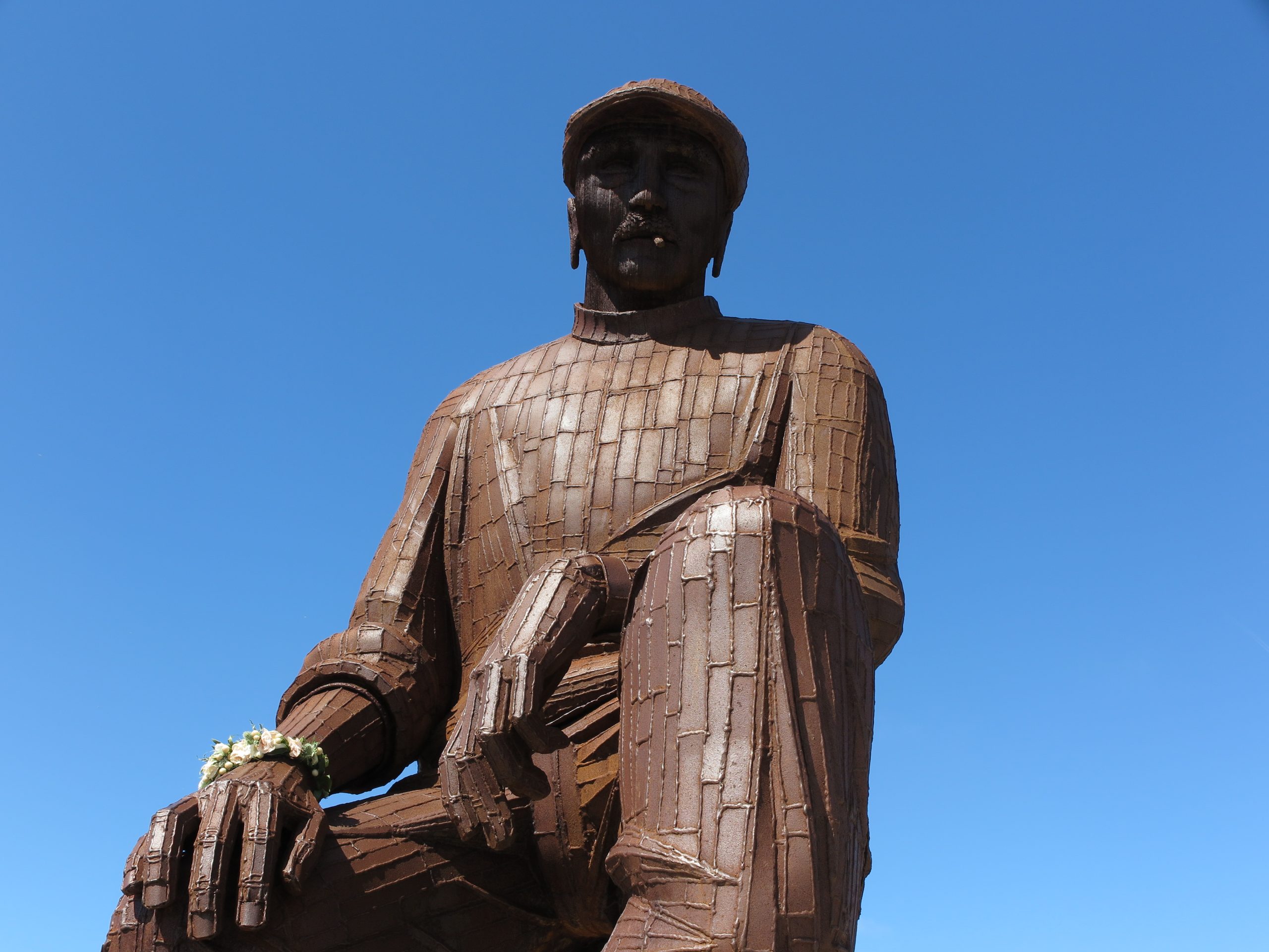
Once past the various eating establishments be sure to watch out for, on your left hand side, the sculpture, also by Ray Lonsdale, which depicts a life-sized herring girl sitting on a barrel holding a fish in each hand. The herring girls traditionally played an important role on this bustling quay, following the route of the herring as they moved south, gutting and salting the fish that were caught and landed here.
On your right is the recently constructed and somewhat convoluted Riverside Embankment Walkway which connects the town with the Fish Quay. It has been nicknamed by some as the Salt Market Walkway as a nod to the popular Salt Market Social venue immediately opposite.
Wooden Dolly
You will soon reach the Prince of Wales public house and the buxom Wooden Dolly, an artwork made out of oak by Martyn and Jane Grubb in the form of an old ships figurehead. Installed in 1992, the work stands on the spot where a wooden dolly has traditionally stood since the early 1800s.
You are now on the final lap of the walk as you continue to follow the road past new riverside apartments and then, to your right, the steep embankments which lead up towards the town centre.
When you reach the bottom of Borough Road take a look at the stone remains standing on the bottom right hand corner, once St. Peter`s Church and known locally as The Sailor`s Church.
A few metres around the corner lie St. Peter`s Stairs giving access to the houses high above the riverside. On the immediate left hand corner stands the former Porthole public house dating from 1897 but in recent years transformed into an office for a firm of Architects.
Market Place
Cut across the bottom of Borough Road, to the New Quay, or Market Place, first laid out in 1770 and the end of the walk.
Before leaving for home look closely at the older part of the imposing building on the north (right hand) side of the road. Built in 1806 by the Duke of Northumberland, it was for many years the home of the notorious Northumberland Arms Inn, known to sailors far and wide as The Jungle.
The corner part of the building, adjacent to Borough Road, was once a sailor`s home, a fact marked by a blue plaque affixed to the river facing façade of the building.
Further along, just opposite the ferry landing, you will notice that the fine tiled façade of the former Crane House public house has been sympathetically retained within the new housing block. The King Charles II England Coast Path continues on the south side of the river, after a short ferry crossing.
Your coastal walk ends here!
Image credit: Geoff Holland